Age of Treason - map scale problem

A

Anonymous

Guest
I recently bought the Age of Treason book. Great stuff; inspired and perfectly suitable for a nice campaign for my gaming group.

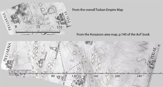
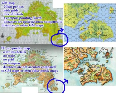
The problem I have though is with the maps. Most (all?) don't have a scale printed on them (in km, miles or leagues).

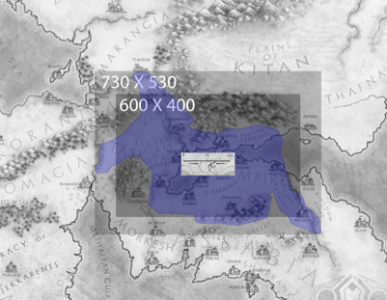
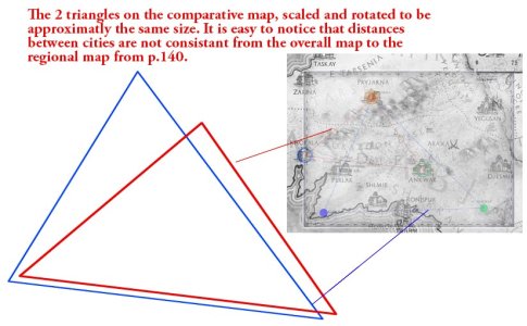
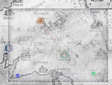
Even worst, one of the only map that does have a scale seems wrong! I am talking about the Taskan Empire Map found on Mongoose's site and other sites. This particular map does have a scale, but with no units indicated... So I presumed it should be miles. But, no: there is a bug...

According to the AoT source book, p.2 the Taskian Empire "spans a territory 600 miles east to west, nearly 400 miles north to south". But when I use the scale on the map to measure the Empire's "bounding box", I get something like 730 X 530. So the scale is definitely not expressed in miles, because it would contradict the AoT book statement, nor kilometers, since it would then be much less than 600 X 400 miles...

So, what do you think: the scale on the map is wrong? The AoT book is wrong? I am wrong?

To some, it may seem like a minor issue, but considering it will affect all travel distances and potentially all future maps published for the game (or the one I will make for my modules)... I see this as an important issue!

Anyone has a clue?
 

Attachments

  • scale_problem.png
    scale_problem.png
    158.8 KB · Views: 4,937
Hi Yan

Both the setting map on the inside covers (also downloadable from Mongoose site, I believe), and the adventure area map, have scales on and they are in miles.

The text description of 400x600 is an approximation in a bit of text that gives you a broad sweep of the size of the empire, and I'm not sure I see the problem, as the 400x600 box you have placed on the map pretty much covers it. Yes there are a couple of bits sticking out. No, the Empire isn't box-shaped.

However - the overall setting map is an illustration, not an ordnance survey map. You should produce a map to a different scale to use for in-game navigation (as per the Adventures map - also see the Sorantia regional map in the Companion book, which is part of the preview visible on the blog.)

I hope this helps
 
Thank you for the answer, Simulacrum.

Just to explain a bit more the confusion, the AoT book says of the North-South Taskan Empire's dimension to be "nearly 400 miles". Which I found was quite an underestimation when my measurements on the map gave me 530 miles; thats a 33% margin of error.

I do understand that the overall setting map is more an illustration than a rigorous survey map, but given the fact that most maps don't show any scales at all (since most of them are derived from the overall map), I just wanted to make sure.

And of course, I understand that the Empire is not box shaped. But "600 miles" East-West is quite different that the 730 miles I measured.

To further add to the confusion: I tried to compare the distances between Pryjarna and Perlak, from the overall map and from the Korazoon area map on p.140 of the AoT book (it has a scale too!). Its hard to be precise, considering the size of the city icons on the map, but if a take the "center" of the icons as a reference I get that the distance between these 2 cities is not the same at all on both maps. In the overall map, Pryjarna and Perlak are approximately 160 miles apart, while they are almost 260 miles apart in the regional map on p.140... Please correct me if I'm wrong, but this time it is a 60% margin of error (granted, it is hard to be precise on "poetic" maps).

Don't get me wrong: I think the provided maps are really gorgeous and inspiring. And the informations on history, cultures and countries in the book are great too.

Its just that, as a game master, I feel I need maps where scales and distances are easy to figure out and consistent from map to map.
 

Attachments

  • mapscales2.jpg
    mapscales2.jpg
    89.7 KB · Views: 4,877
Yan,

I don't accept your point on the 600x400 vs 730x530. I'm entitled to choose my language and my own points of reference. You insist that I must refer specifically to the span between the furthest point in each compass direction and hence my text is at fault, and I insist I didn't (and I wrote it). I'm sorry if that provides a source of confusion to you, but it's part of a descriptive passage that gives an impressionistic overview of the empire the book is about to describe in detail, and your method rather overstates the actual land area involved. If you want to describe it differently to your players, that's your prerogative.

Also, don't read the large map to give you precise calculations of distance, it's simply not there for that. I appreciate that the apparent difference between large map and Adventure map's distance from Pryjarna and Perlak is rather high - but frankly I don't read much of significance into that. If there are disagreements between large and smaller scale maps, smaller scale wins. Other inconsistencies may appear as more small scale maps are produced as new areas are explored and mapped in more detail. If the relationship between two places changes in a way that materially changes (rather than confirms) how they have been represented from a descriptive and narrative standpoint, that would be more problematic.

The (smaller scale) Adventure map is, however, intended as a play aid rather than an illustration - if there is a specific inconsistency between the map and its scaling and matters such as journey times between two points stated in the text, then that is an erratum, and such things are of interest with a view to amendments for future editions.
 
I'm entitled to choose my language and my own points of reference.
Ok. So I'll state that Continental USA (forget Hawai & Alaska for my example) is X miles East-West and Y miles North-South. Sorry for the people of Florida, South Texas, Maine or the San Francisco coast: They are not included in the estimation because they "stick out of the box". :lol:

(...) don't read the large map to give you precise calculations of distance, it's simply not there for that.
So then, why bother to even have a scale on it?

If there are disagreements between large and smaller scale maps, smaller scale wins.
Ok. But lets say my players want their characters to travel from Zaryna to Haran. I don't have currently any detailled map showing those 2 cities, other than the overall Empire map. As a game master, my only reference is a map that is incorrect. Yes I can do some calculations, extropolate or simply decrete what is the distance (maybe the whole world warps from day to day depending on magical fluxes). But I was expecting an official campaign source book would assist me better in these distances estimations.

Please understand that I am not simply 'ranting' here (and I am not angry either): I am trying to point out at a problem that might affect any further developement based on those maps, both by GMs and commercial producers.

I further think that not only the scale on the overall Empire map should be corrected, but the location of cities too. According to some comparisons I made between the overall map and the p.140 map, distances between cities don't agree, even when scale differences are corrected. I scaled the p.140 map so that its scale is the same as the overall map, and superimposed them in a graphic software. I found not only the locations of major cities don't match, but the distances between the cities are not proportionally correct from one map to the other (see my attached files).

So, in conclusion, either the overall map is flawed, or the local map is flawed (even if "smaller scale wins").

You where right in saying that it is the kind of stuff than is usually adressed in an official errata...
 

Attachments

  • compare2.jpg
    compare2.jpg
    99.3 KB · Views: 4,853
  • compare1.jpg
    compare1.jpg
    191.6 KB · Views: 4,853
Is it not possible that the map makers in the Age of Treason did not have accurate tools to make the maps provided?

After all, in the real world maps haven't been completely accurate until fairly recently.

Ortelius.World1612.jpg

Circa 1612


Fun campaign hook: Your adventurers have to go about making a more accurate map of the world for some King.
 
Cyporiean, I see the kind of map you posted as a representation of an extremely accurate map to give as a player handout, or to hang on the wall in my gaming room: it illustrates what an incredibly good map would look like in an ancient world setting, if it was crafted by excellent and knowledgeable ancient cartographers.

But as a GM, I think that my reference maps, the ones I use to plan, measure, evaluate and comprehend the fantasy world, must be much more accurate than that.

I already used the idea to send my PCs on a exploration / cartography mission in another campaign setting. I gave them a so called poetic map (and an incomplete one for that matter) stating that it was a copy of the best map in the realm. They had to travel far and wide for months, exploring and rolling skills to improve the map (for the future glory of the King... and the merchant guild of course!)

The problem is still the same even in an adventure like that: I need more accurate maps as a GM if I want to send PCs on such a mission and be able to track where they are compared to what they see on their own (inaccurate player handout) map.

Personally,I wouldn't mind correcting the overall AoT world map to make it a bit more accurate. But given the distortions in the distances that I pointed out in my last post, the task seems daunting: changing the scale of a map is easy. Moving cities and land features around to make multiple maps fit together is not.
 
I find that in games I run the time/distance between city A and city B is whatever the plot needs. As long as you have a record of it and when the group travels from city B to city A at some other date the time/distance remains roughly similar that works for plot purposes.

I am planning a fresh campaign where I have a map drawn by a graphic artist based on their reading of the books that make up the fantasy author's story cycle. Now I don't completely agree with the positioning of some of the cities and the map has no scale at all so unless there is some internal time /distance scale in the stories (and I don't believe there is) I am going to hand wave time/distances for travel and make them whatever suits the plot. It will work out just fine because the game doesn't revolve around the players or the GM knowing to within a millimeter the distance from city A to city B.

If you have a diagram showing the relationship between areas of an empire or a city then don't regard it as something to be set in stone like a modern map and don't treat pretty pictures illustrating a supplement as canon for an accurate map. We all know that maps prior to the mid 17th century were more a pretty picture showing relationships than an accurate representation of the world so why should an author be required in a fantasy setting that obviously is set in an earlier milieu be forced to do otherwise.

To argue for a fixed and rigid scale for fantasy maps is taking pedantry way too far in a game.
 
I am not asking for the degree of precision found in modern maps.

I don't think it's pedant to insist that a 60% marging of error on the location of major cities from map to map is not a small mistake.

The maps should be corrected by the publisher (errata) and greater care should be taken for the development of future map.
 
To be honest a picture of an empire drawn by a graphic artist is an illustration not a map. If you treat it as a map and find discrepancies with other pictures than that is the illustrators perogative in conveying the feeling that the author wishes to bring to the product.

The only thing that could be regarded as an error is if a table of distances was different to details in the text.

The author of the work has specifically state that the map of the empire is illustrative only and the local map is to be preferred for reckoning distance.

If Christopher Columbus showed Isabella a map showing China a reasonable sail across the Atlantic was the world wrong or the author of the map who provided an illustrative map with distances based on a best guess?
 
To be honest a picture of an empire drawn by a graphic artist is an illustration not a map. If you treat it as a map and find discrepancies with other pictures than that is the illustrators perogative in conveying the feeling that the author wishes to bring to the product.
The maps I am comparing are visibly made by the same artist, or at least they display exactly the same graphic style. If they were from different illustrators and most of all of different styles, then I would agree that discrepancies would be hard to avoid. Honestly, I doubt that the author wanted the map to convey the feeling that distances and scales are not important in maps. Maybe the overall Empire map should be drawned in a different, more "naive" style, with no scale on it, or maybe the more precise local maps should look slightly different. It would then be much less confusing as to which map should be considered accurate and which one should not...

The only thing that could be regarded as an error is if a table of distances was different to details in the text.
I agree it would be an even greater error! But producing maps with the same graphics style and being sloppy on scales and major landmarks locations is also an error.

The author of the work has specifically state that the map of the empire is illustrative only and the local map is to be preferred for reckoning distance.
Ok. Two words then: official errata. Please.

If Christopher Columbus showed Isabella a map showing China a reasonable sail across the Atlantic was the world wrong or the author of the map who provided an illustrative map with distances based on a best guess?
You know, in most RPG Christopher Columbus would be a PC and Isabella a NPC. The PC could show the NPC whatever map he wants, but I suspect most GM would prefer to have (for their own use) the real world map, showing the true distance from Europe's West coast to China as well as the "minor" detail that there is in fact no direct path on the Atantic to go to China...
 
Maybe its me. Maybe I was spoiled by an another world system during my long gamer career.

But I have come to expect that serious world systems should somehow distinguish between 2 kinds of maps (GM and poetic).

A picture here, is worth a thousand words:
 

Attachments

  • example.jpg
    example.jpg
    141.2 KB · Views: 4,781
It seems you really don't get it. I suspect that English may not be your primary language.

The author says that the big map is a pretty picture and the ones designed for specific areas should be used to determine distances and you will not accept the author's statement.

Face it, you aren't going to get it as "official errata" because it isn't, the author said it wasn't and you haven't seen him back to change that statement. You've made an assumption which the author told you is incorrect. The map has an unlabelled scale and to me that makes it not something to use for a definitive distance measuring device. The author explained that and told you which map to use. That's it, no errata.
 
Errors in cartography transcend language barriers.

For your knowledge strega, all AoT maps in the core book that have labels don't display units. Granted it is not a huge problem (it can easily be corrected), denying that it is a problem won't make it go away...

Denying that the maps published so far may potentially lead to confusion in future map development is wrong.

Denying that foundation maps in a gaming system should be corrected when they display no proper scales and have inconsistent landmarks positioning is wrong.

Denial is always wrong: When one doesn't look at the moon, even if he denies its very existence, the moon is still there in the sky.

Much to his credit, the author didn't deny: in fact, he confirmed that the overall Empire map is indeed inaccurate and yes, he pointed out that regional maps were to be taken into account for more accurate distances (see: my understanding of English isn't that bad!). That was an author's precision about an important aspect of a commercial gaming reference book.

And author's precisions about an important aspect of a commercial gaming reference book are exactly what official errata are made of.

Maybe it will be in an official errata (obviously, I think it should). Maybe it won't. Maybe, without anyone officially knowing about it, a little more care will be taken to avoid confusion in future maps. Who knows? I have no reason to doubt the good will and professionalism of the author and his map makers to improve their products.

I still think that the vast majority of AoT material is absolutely wonderful, masterfully written, inspiring and truly has huge potential for the future: I sincerely wish the author and future developers success.

Notice that initially, I just wanted to point out a problem with maps in AoT so that future map development for that game could improve. Nothing more, nothing less.

I think I made my point. At least for people who, like me, are somehow concerned with map making rigor in a fantasy setting.

I'm leaving this thread for good.

Best regards.
 
Ok point clearly made. Accurate maps are better than maps with weirdness on them (for GMs).

Having said that, Simulacrum, if you have to decide between spending your limited development time (A) polishing cartographical inconsistencies in your maps or (B) dreaming up cool stuff in Korantia, the Theocracy or Kitan, please consider this post my vote for (B).

Best regards,

Dan
 
Yan said:
Errors in cartography transcend language barriers.


You are beating a dead horse here Yan, give it up. Perhaps you should be happy the maps are far astoundingly more precise than medieval maps. Further... continued argument can make you look like a jerk. Remember to place nice.
 
In my last post, I said I'm leaving this thread for good. I thought It implied that I won't argue anymore about anything in this thread...thus avoiding to be labelled as a 'jerk'.

(oops!)

Sorry... my bad: I am really leaving this thread for good now...
 
Guy's,

I'm not going to go on too much re this topic, but...

Maps drawn with hexes, grids or whatever are great for GM's who like to know that under normal travel conditions it takes x# of days to travel from point A to point B by y method. If that's your style go for it!

Maps drawn without are purely illustrative IMO, even though they may have a scale bar. There is a fine line between 'artistry' and 'realism'. For me, I use such scales as a guide and determine my own distances and travel times. Generally, so long as 'normal' travel times don't change and you maintain verisimilitude it's all good.

If you really need accurate times and such, pick the map that best suits your purpose - just one mind! - and overlay a grid or hex on it to use for your own reference. I would always go with a textual statement of distance between 2 points, if there is one, than those in an illustration, but that's just me.

I wouldn't class the maps of AoT as errata though. To me they are not drawn for any other purpose other than illustration.
 
Back
Top