My Nearspace Setting

Tom Kalbfus

Mongoose
I've been working on this 3-dimensional near space setting, here is a map and list of sunlike stars within 50 light years of Sol, similar to the 2300 map, but I've left out most of the red dwarfs, this map shows class K and higher in the main sequence, and if a red dwarf is part of a multi-star system who's primary is K or higher, then the class M red dwarfs are included, otherwise they're not. Here is my map, not finished yet, but here it is:
stars_within_50_light_years_by_tomkalbfus-dahcy4q.png

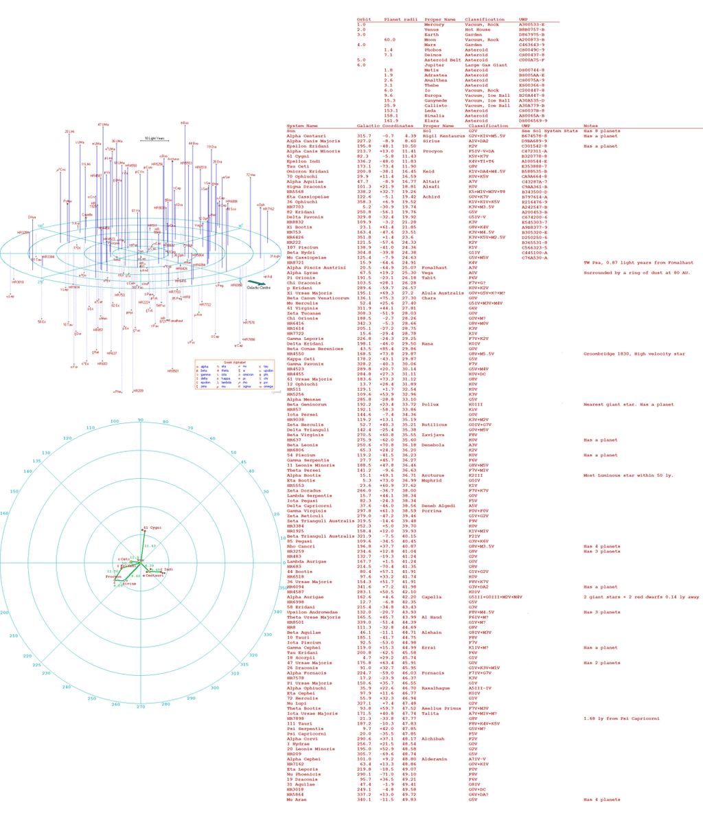
the top map shows the stars in three dimensions, I found this one on the internet, using the galactic coordinates supplied at that site, I plotted some stars in a top down view. the green trade routes have green numbers which show the distance in light years between the two systems connected. Those trade routes are actually wormholes. Our Solar System has 5 wormholes leading out of it, each wormhole has a mass of 1.2 * 10^25 kg, nearly the mass of Neptune. The wormholes are in orbits 10, 11, 12, 13, and 14. There net masses are each 1.2 * 10^25 kg, but there is a lot of negative mass surrounding a lot of positive mass. The actual wormhole is 1 AU in diameter, and has an opening that starships can fit through that is 1 km wide. The cloud of negative mass surrounding the opening, negates the solar mass opening in the center, which has 1 Solar mass+ 1.2 * 10^22 kg, while the negative mass cloud has -1 Solar mass. Since gravity pulls on all matter in proportion to its mass, this slightly greater posive mass holds the cloud of negative mass into a spherical ball about 1 AU in diameter, this negative mass is dark matter, that means it can't be touched, solid objects pass right through only interacting gravitationally with it. As one moves closer towards the center of the wormhole, the mass in the center seems to increase as there I less and less negative matter between the observer and the wormhole throat. One falls through the throat, and momentum carries out out the other end of the wormhole through the cloud of negative mass at the other end, and the apparent wormhole mass will seem to diminish as one moves further away once again.

Who built these wormholes? They were discovered by humans, not made, this occurred when gravitational influences of invisible bodies were detected, so a search for a planet ended up detecting these wormholes instead. The wormholes are fairly stable, and impossible for humans, even at tech level 15 to destroy. You can detonate a nuke in the throat of a wormhole, and the radiation simply spills out both ends of the wormhole without damaging it. There is nothing solid to damage, only gravity and dark matter.
Here is a close up of the map portion, so you can see it more clearly:
50_nearest_stars_map_by_tomkalbfus-dahd0p9.png

Here is the list of worlds, I have so far rolled up:
50_nearest_stars_list_by_tomkalbfus-dahd17l.png

I hand-rolled the stats with physical dice, they are mostly random, except for the ones in the Solar System, which I contrived to match the physical characteristics of the planets. As you can see, the Earth is a bit of a backwater, the main "world" in the Solar System is actually the Asteroid Belt, with a population in the tens of billions, and its capital and class C starport on Ceres. The Main Belt is Balkanized into several nations, but hey joinly operate the Belt's starport, and have a UN like semi-government organization, where they hammer out agreements between each other. The wormholes were discovered by these Belters, prospecting for more asteroids in the outer solar system, when they found an absence of Kuiper belt objects in certain orbits, they got suspicious and discovered these wormholes. The wormholes are the only means of "FTL" travel in this setting.
 
-Daniel- said:
Wow, that is a bit of work. I love the idea of 3D maps, just never used them in game. :D
Actually I did the map at the bottom, I don't claim credit for the top map, which I got from the internet, as well as the statistics for the stars which aren't UWPs. The wormholes are just one way to go. its possible to calculate the distance between any two stars with the information on the list. The first coordinate is the longitude (360 degrees) along the galactic plane, the second one is the azimuth, the degrees incline rom that plane either positive (+) toward Galactic North, or negative (-) toward Galactic South, the last number is the radius or distance from our Sun, this is measured in light years. the way you calculate distance is to convert these into x,y,z coordinates and then use the Pythagorean distance formula t find distance. The x,y,z coordinates are determined thus:

x = distance * cos(azimuth) * cos(longitude)
y= distance * cos(azimuth) * sin(longitude)
z= distance * sin(azimuth)

you find x1, y1, z1 for the first star system and then you find x2, y2, and z2 for the second star system, and you can calculate the distance between the two wit this formula
distance = ((x2-x1)^2 + (y2-y1)^2 + (z2-z1)^2 )^0.5

For those who don't want to do this everytime the PCs make a jump, just use the established routes where I pre-calculated the distance.
 
Impressive!

I tried something similar a long time ago, but gave up long before I came as far as you have.

A spreadsheet and a tablet should sort any calculation needs at the table. I would convert everything to cartesian coordinates (x,y,z) instead of polar coordinated (r,φ,θ), it makes relative distance easier to spot. It also makes it easier to divide space into cubical sectors and subsectors.
 
AnotherDilbert said:
Impressive!

I tried something similar a long time ago, but gave up long before I came as far as you have.

A spreadsheet and a tablet should sort any calculation needs at the table. I would convert everything to cartesian coordinates (x,y,z) instead of polar coordinated (r,φ,θ), it makes relative distance easier to spot. It also makes it easier to divide space into cubical sectors and subsectors.
I had a spreadsheet, but then my computer started acting up, so I returned it to the factory setting, and as a result I lost my spreadsheet program, so I use the calculator program instead. The thing is, when you do it by hand, if you make a mistake, it only effects that one instance, instead of being repeated many times by the computer. My plan is to leave everything a spherical coordinates, I create a bunch of travel routes with the pre-calculated distances. The process of calculating distance includes an intermediate result of converting it to x,y,z coordinates on a case by case basis. I'm not planning on having cubic sectors. When you do 3-d maps, you keep it local, there would be millions of stars to chart if I did in on the scale of the OTU map.
 
I've found the 3D maps to be pretty interesting to look at. But from a gaming perspective, travel between the stars is of no real consequence. The only difference it makes is when you are trying to plot your established paths between systems, telling a player that they can't travel directly from A to C without first stopping in B due to spatial geometry.

Other than that the 3D map can be confusing without being able to rotate it to change your point of view. Which defeats the purpose of printing it.
 
Well if they are real stars around Sol, then they have to be placed in their correct positions, and their correct positions aren't in a 2d plane. The travel routes are the most traveled routes, if the players want to go anywhere else, they have to calculate the distance as I showed, that is the astrogator's job anyway. So we designate a player to be the astrogator, and he does the calculation prior to the ship making a jump. What's wrong with that? Adds a bit of realism to the game, don't you think?
 
Tom Kalbfus said:
So we designate a player to be the astrogator, and he does the calculation prior to the ship making a jump. What's wrong with that? Adds a bit of realism to the game, don't you think?
Trivial calculations are a job for computers. I would get tired of doing it by hand or calculator half-way through the first time.
 
AnotherDilbert said:
Tom Kalbfus said:
So we designate a player to be the astrogator, and he does the calculation prior to the ship making a jump. What's wrong with that? Adds a bit of realism to the game, don't you think?
Trivial calculations are a job for computers. I would get tired of doing it by hand or calculator half-way through the first time.
Which is why I'll let the players do it on an as needed basis. I already got the coordinates in Spherical Galactic coordinates of Type K and greater mass stars out to 50 light years. All the information is there should anyone wish to calculate the distance between any two stars, I might not even complete my map. I have all the stars, I just need to generate main worlds for them, I'll roll some dice, first for the primaries, and if I feel like keeping on going, I'll generate main worlds for the companion stars as well. Our Solar System has main worlds generated for Mercury through Jupiter, with the stats for the major moons of Jupiter, and for Phobos and Deimos of Mars, generally anything smaller than a size 1 world, I consider size S if they are only one body, if they are a ring around a planet, they are Size R, and if they are an asteroid belt, they are size 0. Size 0 and R are always multiple objects of Size S individually. Size S is anything less that 500 miles or 800 kilometers in diameter, Size 1 is from 500 miles to 1499 miles or from 800 kilometers to 2399 kilometers and so on.
 
I have been playing with 3D maps of near space for a long time. Excel or another spreadsheet can pretty easily handle the distance calculations for you once you set up the table. From that, you can decide on your exploration and colonization patterns.

I don't use Tom's wormhole ideas, if I want to keep it Travelleresque, I use either parsecs (really limited routes) or I just expand the range of the Jump Drive to 5 ly per jump or maybe even 10 ly if I want a very space opera-y game.

The biggest challenge is the number of stars in the map gets really big really fast as you try to make it bigger. If you want to show every star, then 20-25 ly cubes seem to work out best, with 30-40 stars. If you go only for the "habitable" stars like Tom did, then you can make it a bit biggers, but not much more than 50 ly. With a decent Jump range, you get a lot of maps very quickly and you can easily see why Traveller chose to go 2D for simplicity.

SHAMELESS PLUG ON
Stellagam Press has published a 2-D Near Sol star map for use with Traveller. Available at DriveThruRPG now!
SHAMELESS PLUG OFF

:)
 
Rikki Tikki Traveller said:
I have been playing with 3D maps of near space for a long time. Excel or another spreadsheet can pretty easily handle the distance calculations for you once you set up the table. From that, you can decide on your exploration and colonization patterns.

I don't use Tom's wormhole ideas, if I want to keep it Travelleresque, I use either parsecs (really limited routes) or I just expand the range of the Jump Drive to 5 ly per jump or maybe even 10 ly if I want a very space opera-y game.

The biggest challenge is the number of stars in the map gets really big really fast as you try to make it bigger. If you want to show every star, then 20-25 ly cubes seem to work out best, with 30-40 stars. If you go only for the "habitable" stars like Tom did, then you can make it a bit biggers, but not much more than 50 ly. With a decent Jump range, you get a lot of maps very quickly and you can easily see why Traveller chose to go 2D for simplicity.

SHAMELESS PLUG ON
Stellagam Press has published a 2-D Near Sol star map for use with Traveller. Available at DriveThruRPG now!
SHAMELESS PLUG OFF

:)
90% of stars are class M red dwarfs, a typical habitable planet might be like the one that was recently discovered orbiting Proxima Centauri. A few typical habitable planets orbiting red dwarf stars might look like these:
5405_ca6ab34959489659f8c3776aaf1f8efd.jpg

eyeball_earth1.jpg

5406_ee389847678a3a9d1ce9e4ca69200d06.jpg

The bottom two are water worlds, these worlds do not rotate with respect to their primaries due to tidal lock, therefore their far sides tend to be frozen and covered in ice sheets, in the case of a water world, the ice sheets provide a solid surface to build upon, if the planet is far away enough from its sun, that ice will creep around the terminator over to the day side. Human colonists would probably want to live on these ice sheets in homes that are half submerged in the water/ice, for shelter against the frequent stellar flares, that such stars often give out. Water/ice makes good radiation protection. People might get tired of seeing these same sorts of worlds over and over again, since 90% of all stars are red dwarfs and planets in their habitable zones will tend o be tidally locked with limited optimal areas for living. There are enough multistar systems in my map to give a far smattering of red dwarf planets, including Proxima Centauri by the way.
 
Rikki Tikki Traveller said:
Very nice images. Where did you get/make them?
The 3-d picture cam from this website:
http://www.atlasoftheuniverse.com/50lys.html
50lys.gif

it is accompanied by a list of naked eye stars within 50 light years, not including the red dwarfs unless they are part of a multiple star system with a brighter star which qualifies to be on this list. I don't want 90% of my worlds to have red dwarfs as heir primaries anyway, that gets kind of boring after a while.
The other map is a top town view of the x-y plane that you see in the 3-d map, I use that to draw my trade route indicating distances. But with the information in this website, you can calculate the distnces of any two stars, not just the ones connected by trade routes.
 
Here is a small hex map of my Near space setting:
local_stars_around_sol_by_tomkalbfus-daiih12.png

The hexes are numbered according to their position, the first number is the up or down position, which defaults to 0 when the hex is empty.
The second number is radius in hexes. (Each hex is 1 parsec across)
The last three numbers is the degrees in a right-hand circle. (counter-clockwise)
 
Back
Top