Planet Map: Damadas

Hexes generated in Inkscape, theres a nice hex creator add-on around.
Colours, text, lines etc in Illustrator, nice thing each hex is fillable, so edit is easy.
Then export as PSD and open in Photoshop, added the textures and some shading

Heaven and Hell generated the specs. Yes it does work under Windows 7 !

Next plan, crinkly bits..
 
Not used Hexographer, but I will look, its got better icons...
Think is I can do some funky photoshoppping with this one..and its ridicously hi rez

Bit of a random test:- cosmic pack, flexify and an overlay
klax-ii.jpg
 
I can't remember how I did it now (probably could though with less Bacardi clouding my brain), but I used to have a programme that exported vector maps of planets, then took them into 'Flexify'... and voila, contour maps in an icosohedral form. Could be ridiculously detailed.
 
Lord High Munchkin said:
I can't remember how I did it now (probably could though with less Bacardi clouding my brain), but I used to have a programme that exported vector maps of planets, then took them into 'Flexify'... and voila, contour maps in an icosohedral form. Could be ridiculously detailed.

I use flexify to create the isomap... I'm liking your idea, might have a looky...

Some of the detail is added in photoshop ie the ice caps... and I've not quite got the flexify to work some fixing is required... ie remove seems, add crinkly bits ;O)
 
If somebody offered a PDF product which contained, for a number of worlds (say 10, or 20, or 50 in a deluxe model) each of which was detailed with:

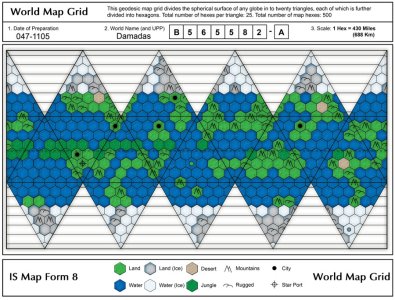
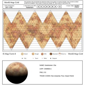
A hex map using IS Form 8 with form fillable bits for the planet name, date, UPP profile (except hydro which would be based on the map) and scale
A render of a view from orbit with a ship, moon, comet, satellite or something to give some variety
Maybe some colour variant versions so a desert world map could use all yellow, brown, grey and a normal garden world could use teh same base map (differnt hydro profile) with greens, browns, blues
Some graphic renders of different gas giants - no maps needed

I would pay cash money for such a poduct.

PS - Lovely artwork above. Produce more of it, package it, and sell it to me. Please :)
 
crazy_cat said:
PS - Lovely artwork above. Produce more of it, package it, and sell it to me. Please :)

Thats the plan... ;o)

So you'd be ok with say 10 blank worlds ? Then 20 ...
I can do a subsector like this....perhaps too... or something. Oh ideas..

I've another ship book to finish.. but I keep get distracted by building worlds ! Damn you Slartibardfast !
 
I love the last view, being somewhat photo-realistic, plus seeing the planet in orbit. But I wonder if the nebula in the background is a bit much. I do not recall seeing any background details of real camera shots of the Earth, as the sun's light blots out everything else.

I'd buy such a book. I'm fascinated with planetary development and eat up anything involving Earth's past, especially artistic views of the continental formations of the past, and what the creatures were like back then. You could put Travellers back into Earth's far past and they would think it's another world entirely, although the moon would be a give away. :mrgreen:

I could see having two, or more, planetary maps: one being the photorealistic one (what you see when you come into orbit), and a political map (outlines of the nations or factions depending on the government), that includes population density, cities, and starports.

Each planet should have a plot hook and NPCs as well.
 
GamingGlen said:
I love the last view, being somewhat photo-realistic, plus seeing the planet in orbit. But I wonder if the nebula in the background is a bit much. I do not recall seeing any background details of real camera shots of the Earth, as the sun's light blots out everything else.

Yeah normally I avoid too many stars being seen or nebulas... that a posey desktop version!
;o)
GamingGlen said:
I could see having two, or more, planetary maps: one being the photorealistic one (what you see when you come into orbit), and a political map (outlines of the nations or factions depending on the government), that includes population density, cities, and starports.
Each planet should have a plot hook and NPCs as well.

Thats something I can do, I was looking at the earlier coloured hex version and seeing I could still do that so you can see the terrain types clearly and urban areas etc...

Watch this space... 10 worlds 1 book... Slartibardfast eat your heart out!
 
Sorry to bring this back up, but... what happened to that book idea? Any more planets I can stea... er borrow? :mrgreen: I suppose I could figure it out how to do it myself.

I'm detailing a group of worlds, known collectively as "The Cluster" * (as opposed to "the 'Verse" :wink: ) for a campaign I'm setting up and was thinking of this thread. Took me awhile to find it again.


* using the Imperial Trade Cluster in the Gateway to Destiny book, but setting it in the year 820 so Imperial annexation is still a sore spot for some, especially on "Joining Day", and that the Imperial Psionic Suppression policy is ongoing to provide some *ahem* situations. :D
 
Back
Top